Photo Album (August 7) | Video Tour (May 30)
--
Ready or not, here it comes! There is a brand new cross country course springing up in Polk County and its potential is immense. The raw piece of land is starting to take shape, as its opening day quickly closes in. The Jim Ryun Invitational will be held at the not-yet-opened private park on September 14-15, 2012.
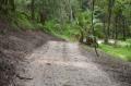
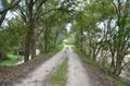
The last time I visited back in late May, "raw potential" was an understatement. So how does it look now? Todd and I headed back there today (August 7) and met up with meet director Paul White and generous benefactor, Ed Holloway, at his office at Sanlan RV Park. Mr. Holloway drove us on a tour of the course's progress in his 4x4 truck. His crew has been busy since June! They have been cutting trails, moving dirt, carving passages in sides of hills, and dragging it level. The trails throughout the property are for the most part in really fine condition: another layer of dirt, another session of dragging it level, a month's grass growth, and light sprinkle of pine needles and leaves and they will be perfect for running. The area that continues to need to most T.L.C. is the starting and finish straights. Paul and Ed assure me that they'll have no issue getting it in order in the five weeks remaining. For this part of the course, there are no trees or brush to clear. It's just about moving around the dirt and leveling it out.
So here is a little bit about the course and why we are so excited about it...
History
The cross country course sits on land that was mined for phosphate until the late 1940s. Ed and his wife Mary Ann Holloway purchased the property, along with hundreds of acres adjacent to it, in the early 1970s. The years of phosphate mining left the land riddled with hills, ridges, and valleys. Since that time it has become heavily vegetated and utterly beautiful!
Just to the south of the Polk Parkway, the Holloways have developed the rest of their 1970s land purchases into Sanlan RV Park, Bramble Ridge Golf Course, Sanlan Recreation Area, and Sanlan Bird and Wildlife Sanctuary. Most of the Holloway's property to the north of the Parkway has remained undeveloped up to this point, except for the Cypress Youth Sports Complex. That youth soccer and football complex opened earlier this year off of Edgewood Drive from a 33-acre tract donated to the county by the Holloways.
For years Mr. Holloway has dreamed of turning 220-acres of the property into a public park with a trailhead, serving to connect the Fort Fraser Trail, Circle B Reserve, and Lakeland's Lake-to-Lake Trail. However, after years of pressing the local and county government, it has become apparent that the county has no interest in the estimated $1.7 Million expenditure it would take to build overpasses across US Highway 98 and the Polk Parkway. Without these there would be no safe way to deliver pedestrians over the main thoroughfare. Instead, the county commission discussed spending an astounding $500,000 to STUDY the possibility in 2014... but that's another story!
With the hopes of the trail connection looking doubtful, Mr. Holloway's vision started to evolve into developing a series of trails on the property itself and opening it as a public park. Whereas linking with the public trail system would have created paved trails, the new idea Holloway had was to leave it more natural and give the public a way to escape the concrete jungle.
Two years ago, the Florida Youth Running Association was looking for a new cross country course to replace Sun 'n' Fun Fly-In after that facility double-booked and kicked us out just a couple months before the second annual FLYRA Middle School State XC Championship. Remembering that during my college days at Florida Southern we had sometimes trained at Sanlan RV Park and held a number of small college meets there, I mentioned this to state meet director Laura Fredrickson. She hooked up with Holloway-owned Sanlan Ranch and moved the course very successfully to that facility--less than a mile south of our new course.
Through talking with Sanlan director Garry Hoffman about the Sanlan course, I learned about Ed Holloway's concept of his property to the north of the Polk Parkway (the proposed Holloway Park). Hoffman described it to me and talked about Ed Holloway's openness to developing it into something special and devoting the resources to make it happen. It sounded beautiful! After surveying the land from the surrounding roads and on Google Maps, I was convinced... this would make an amazing cross country course! As nice as the Sanlan property was, this really seemed like where we wanted to end up eventually.
Back in April, I discussed this property and vision for it with Jim Ryun Invitational meet director Paul White, and he really picked up the ball and ran with it. He wasted no time reaching out to the brilliantly generous Holloway and the two bonded over the property's potential. In a few short months, they've visited the land countless times and started breaking ground on the new course.
The Holloway Park property, as well as the Sanlan Bird & Wildlife Sanctuary, are now owned and managed by non-profit organizations founded by the Holloways. In 2011, they established the Holloway Park Foundation, Inc. to develop and manage the land for the good of society in perpetuity. The great thing is they have the staff, equipment, funding, and desire all right there! Great things can happen in a short period of time when you remove government involvement and have the right resources!
Location
Besides its natural beauty, one of the best things about this property is its location! While most "true cross country" courses you have to drive 30-45 minutes outside of civilization to finally arrive, this place sits really in the heart of south Lakeland. It is encircled by four major local thoroughfares: Highway US 98 (Bartow Road) to the east, the Polk Parkway to the south, Lakeland Highlands Road to the west, and Edgewood Drive to the north.
Literally right next to the course, along Lakeland Highlands, you will find Lowes, Sams Club, Winn-Dixie, Bealls Department Store, and Sun Trust Bank. Edgewood Drive features South McKeel Academy, the new soccer complex, and little shops and restaurants. Going north along Highway 98 and its side streets there is a Pizza Hut, gas stations, McDonalds, and other little restaurants. Florida Southern College, Southeastern University, and Lakeland High School are just off of 98 a couple miles north. To the south on 98 are Polk State College/USF, Sanlan RV Park, Publix, Burger King, a bike shop, Advanced Auto Parts, and numerous other conveniences.
What about lodging and more dining options? Not a problem! Just one exit west on the Polk Parkway is Florida Ave., which is the main north-south road in Lakeland that has a huge amount of dining, shopping, and lodging options. One more exit west on Polk Parway takes you to Harden Blvd., which is really where you want to be! In the last decade they constructed the massive Lakeside Village at this intersection. It is one of those new huge outdoor downtown mall areas. In the complex and surrounding areas you will find all usual chain restaurants of all genres of food, three hotels (Courtyard, Hampton, and Residence Inn), Target, clothing stores, Kohls, a movie theater, and some nicer dining options like Grillsmith. Another exit down the Parkway is the Lakeland Linder Regional Airport and a very nice Hilton Garden Inn, which I've stayed in multiple times in recent years for FLYRA meetings and the state meet.
Lakeland itself is centrally located in the state, near the dead-center of the state population wise. It is half way between Orlando and Tampa on I-4 and not far from I-75, US 27, US 17, and Highway 60. The Polk Parkway is a major (toll) expressway that makes an easy loop around Lakeland (right past the course) and connects back up with I-4 on either side of town. The new Legoland amusement park (formerly Cypress Gardens) is in nearby Winter Haven and Disney World, Universal Studios, Sea World, or Busch Gardens are less than an hour away.
Parking and Getting Into Holloway Park

There will be two entrances into the new park and cross country course. The main entrance will be at Lakeland Highlands Road and Glendale Street, across from the fire department. It will enter the park from the west. Parking will be on the left (near Cypress Youth Sports Complex and immediately next to the start/finish midway area) and the course will be on the right. The secondary entrance (which may be for buses only) will be from US Highway 98 via Marion Drive (which is at the traffic light at 98 and Combee Road).
The path into the venue will not be paved, at least not at first. However, it will be hard-packed ground or graded dirt and access should not be a problem even for buses. Parking itself will be plentiful--there is a ton of land here--and the walk from the parking lot to the midway area and course will be trivial.
The Course: Runner's Perspective

Map above is tentative. Click it to make it larger and in new window.
This is not your standard, pancake PR course! This is a true cross country course in every sense of the word. You will be running through trails and over hills throughout the entire length of the course. They are going to have 3K, 5K and 8K courses from day one... and eventually perhaps 6K and 10K courses if it proves a potential collegiate championship type venue. It is also a single loop course with no overlap (which also means we could potentially start multiple races as quickly as eight minutes apart).
The start will be wide enough to accommodate at least forty boxes. After the start runners will have about 150 meters of relatively level land before headed up a pretty sizable climb. It will be a long incline that you'll feel even with the initial rush of adrenaline of the start of a race. There the path will gradually narrow but continue straight and wide enough for about 550 meters before the first left-hand angle into the woods.
From there, they will start one of three "fingers" of the 5K course. Runners will loop out through some really pretty (and shaded) land and head through some canopied trails, as they head back north toward the waiting spectators around the mile mark. Next they take a right angle to the east along the low trail. This is a really interesting formation of the course. Spectators will look down on the runners from a trail at the top of the ridge, while the runners head out on the trail below. Then the 5K runners will take another right turn for the "second finger" of the course, while the 3K runners will cut it off and keep straight.

Runners head to the east, around a deep lowlands area and around a little "knob" hill that is pretty cool looking. On the map you'll see at this point the 3K course will again cut off and head back north and then west. The 5K runners though will continue out a bit on the "third finger," around another wooded area and toward the back part of the course. Unfortunately, we had to cut this part of the course a little shorter than we wanted--it's really pretty country back there--but the longer races (6K, 8K, 10K) will head further out that way. Even with the cut back, that trail takes you to some nice wooded areas and canopy.
At the end of this finish trail, you kind of reach a point where you see the light at the end of the tunnel. Literally. You're in this canopied trail that is very well shaded and then all the sudden around a bend you look up... up this final climb back up the ridge and you see sunlight that shows you the way to the finish. Now you know you've got about 450 meters to go. You hear the crowd getting louder and emerge from the hill into the open start/finish area and all of the tents. The course cuts back right (north) and makes a loop around and past the vendors and tent city and the back south to the finish.
The Course: Spectator's Perspective
The spectators have a massive area to "live in". This has been architected the same way you have seen me do at Chain of Lakes. We create the same effect by sandwiching and consolidating the foot traffic into one area, which I call the "midway." On the north side of this, there are plans to build a permanent building with outdoor stage, restrooms, and concessions. This is the area were awards will be held, meet packets picked up, t-shirts sold, refreshments available, and vendor booths could set up shop at large meets. Beyond that will be a massive village of team camps: Tent City.
From this hub and without walking far you will be able to see the start, one mile, 2.8 miles and finish. The south part of this Tent City, where the trials start, is at the top of a ridge. So from that vantage point, you are looking down at the start and finish straights. In other words, you have a very large field of view to see a lot of this part of the race.
Back near the finish, we designed the last little finish loop (again very reminiscent of Chain of Lakes Park, where we currently hold the flrunners.com Invitational) to take the finishing runners north and then looping back south again to the finish. This lets fans see a little more of the finish and also allows them a bit more time to get off the ridge trail and over to the finish line.
In our design of the course Paul, Ed Hollway, and I not only aimed for a single-loop course with no overlap... but also for a course where spectators at no point have to cross the course! There are no crossing guards necessary anywhere! Now the nimble coaches, fans, or runners will still have the opportunity to venture out to the far reaches of hte course. Ryan Raposo, upon just two minutes of looking at the course map, already had figured out his route. You can head out some of the other very navigable paths (in blue on the map) that will only be used for spectators. This can take you to some of the outer reaches of the course (about .75 mile mark) and then if you cut across the course into some of the other trails, you can easily get to two points on the second finger (between 2K and 3K marks) and still have enough time to get back for the finish.
Challenges and Future
There are still some challenges yet to meet, even to pull of the September meet. But looking past that smallish meet, there are bigger things ahead.
At this point, there is no electricity or running water out at the course. These of course are not unique to this facility and can be worked around. However, one of the primary goals to make this a real championship venue is to get a water line and electricity run out there. I think both can be accomplished; however, it is quite a distance from the main roads and the City of Lakeland has been a little reluctant to this point. Hopefully soon though they will see that the huge benefit and economic impact this venue will have on the community makes it a no-brainer.
There are also plans to construct a building near the start/finish that will house permanent restrooms, concessions, storage, and an outdoor stage. Mr. Holloway plans to fund these and Paul White's construction company can build them near cost. So this should hopefully be accomplished (along with the water, sewer, electricity) hopefully by the 2013 cross country season.
The roads in and out of the facility need to be graded, if not paved and with two lanes on either side of a median, in order to host major meets. And the parking lot ideally would be also.
There is much hope that this venue can become one of the finest true cross country courses in not only the state of Florida but the entire nation. So the ground work is being laid for hosting major invitationals, district, regional, and county championships. There is also some consideration to bidding for the state cross country meet and NCAA conference, regional, and even national championships (several years in the future).
We are trying to do this right from the start, paying close attention to detailed planning, and getting the right people involved. The opportunity is amazing and unique. A generous benefactor has decided to give the world and specifically our cross country running community a great gift. He has extended his land, money, energy, and resources to build a dedicated cross country course. And he wants no money in return. How cool is that?
Thank Yous
First and foremost, we have to extend a warm, heart-felt thank you to Ed and Mary Ann Holloway for making this dream even possible. I had the distinct pleasure of meeting the man today and he definitely lives up to the hype. Warm, generous, and just wanting to leave a positive legacy on the community that he says has given him so much. Thank you also to his staff and crew and to Sanlan director Garry Hoffman.
Awesome job to Paul White for taking point on this and driving the initiative to work day in and day out with Mr. Holloway to take this from the planning stages to moving dirt around!
Kudos to Laura Fredrickson of FLYRA for kind of opening the door by working with them at their Sanlan course and helping further introduce them to cross country. I think we've got them hooked! Laura is going to (most likely) move the state cross country meet from Sanlan to Holloway Park for the November race. She has also taken her time to meet with Mr. Holloway and tour the course.
We are also getting great support from Marc Zimmerman and Polk County Sports Marketing, a branch of the Visitors & Convention Bureau. The are the best in the biz and have been since I held the first three years of the flrunners.com Invitational in the county back early last decade (I also interned with them while I was attending Florida Southern College). McKeel Academy, Lakeland Christian, Florida Southern College, and other area schools and coaches have also been great and spent time out touring the course and discussing to flesh out the possibilities.
NOW LET'S MAKE THIS THING HAPPEN!
More Coverage
- Photo Album from August 7, 2012 Course Tour
- Video Tour of Holloway Park from May Visit
- Middle School XC Championship Finds New Home (when it moved to Sanlan)
- Jim Ryun Invitational Meet Page
- FLYRA Middle School State XC Championship
- Holloway Park Homepage
- Rough 5K Course on G-Map Pedometer
- Rough 3K Course on G-Map Pedometer